
GPS systems may have taken a permanent seat in our lives, but society will always have a use for maps--if not the conventional kind. One use for mapping is to allow for better organization and display of stats, which might explain some of these innovations in maps like fornication-flagging maps, live shopping tracking and salacious spending maps.
On the other hand, maps can provide artistic inspiration such as in the case of hand-pierced map jewelry and geographic shelves. Click through this collection of innovations in maps to see even more unique and modified ways to map!
73 Modified Maps
Innovations in Maps, from Colortastic Literal Maps to Subway Skirts:
Katherinev123 — Jun 2, 2010 — Pop Culture
73
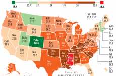
Regional Obesity Trends
The Fattest US States + 22 Obesity Trends

72
Location-Based Social Mapping
Loopt on Your Mobile

71
Fornication-Flagging Websites
IJustMadeLove.com Creates an International Sex Map
70
Music-Map
The Coolest New Way to Find Music You'll Love
69
Map Phones
Google Launches The G1 Phone
68
Clustr Maps
Geo Locate Visitors to Your Site
67
Beer States
Branded Label Map
66
Swarm Maps
New Way to Browse the Web
65
Trend Forecast Maps
Geography by Innovation is Better Than the Weather Network
64
Google Maps for Mobile
Cell Phone Knows Where You Are
63
Earthly Map Creatures
Images Created From Geographic Shapes Without Touching Scale
62
Cartographic Clothing
Elisabeth Lecourt's Map Dresses Will Help You Get Around
61
Geographic Dishware
Map Plates
60
Custom Fantasy Lands
Kindlandia Map Creator Lets You Design Your Own World
59
Gas Price Maps
GasBuddy
58
Suggestive Gayvertising
The Black Tulip Gay Hotel's 'Anal' Floor Map
57
Low-Tech Zoomable Maps
Map Squared Unfolds to Detailed Areas
56
Heat Map of the Homeless
Can You Say Big Brother?
55
Recycled Map Envelopes
Learn Geography, Send Your Letter
54
Interactive Bombing Maps
Carlos Labs Scary Scenario Maps Lets You Test Virtual Weapons
53
Hand-Pierced Map Jewelry
Hannah Lamb's Personalized Rings Follow Shape of Any Coastline
52
Interactive Olympic Maps
Medal Count From 1896 to 2004
51
Gmaps Pedometer
Let Google Track Your Run
50
Disney Google Earth Tour
3D Virtual Disney World (UPDATE)
49
Colortastic Literal Maps
The 'One Planet Version 3' by Harajukumatt is a Treat for the Eyes
48
Projecting Maps
The Maptor Shines On a Wall to Show You the Way
47
Horizonless Projections
Here & There Maps Show Uptown & Downtown Manhattan
46
Erotic Map Art
Carlos Dagorret 'Unusual Atlas' Series Maps Out Human Sensuality
45
Map-Making Mats
'Dimension' Floor Memorizes Your Frequent Walking Patterns
44
Geographic Shelves
'Oh, The Farmer and The Cowman Should Be Friends' Bookshelf
43
Wiener Subway Maps
Michael Hertz's Re-Designed Map Isn't Well Endowed
42
Flashlight Maps
Owen Song's Light Concept Guides You Through Your Adventures
41
Daylight Maps
Google's World Sunlight Map Shows Where Its Day and Night
40
Cell Phones to Map Environmental Pollutants
PEIR by UCLA
39
Teen Star Tourist Maps
The 'Bieber-iffic! Map to Stratford' Capitalizes on Bieber Fever
38
Satellite Sea Bottoms
Google Earth Now Shows The Ocean Floor on Bathymetric Maps
37
Informative Rain Protectors
The Umbrella Guide Master Keeps Out the Water and Disorientation
36
Virtual Mindmapping
'Personal Brain' Software Opens up the Realm of Information
35
Clothes Made of Paper Maps
"Les Robes Geographiques"
34
Papyrus Ski Maps
The MYWAY Scroll
33
Spiderweb Topography
New York City Cut Out Map Shows the Five Boroughs in Mind-Boggling Detail
32
Scrunchable Maps
The Crumbled City Map by Emanuele Pizzolorusso
31
Data Mining Google
U.S. Circulatory System of Highways
30
Local Fresh Food Locator
Local Harvest
29
Interactive Eco Awareness
BreathingEarth
28
Location-Mapping Earrings
The Fluid Forms Streets Earrings Help You Show City Pride
27
North American Obesity
The Skinny on Canadians
26
Glowing Globe
3D Atlas & Constellations in One
25
Online Cartography
Kevin Kelly Interprets the Web With the ‘Internet Mapping Project'
24
Google Earth Tours
Disney World Interactive Mega Map
23
Geotagged City Centers
The Geotaggers' World Atlas Reveals Where People are Snapping Pics
22
Very Detailed Street View City Tours
MapJack Leaves Google Lost
21
Helpful Umbrellas
'The Guide' Shows Tourists the Way
20
Stamp Maps
Marc Alcock Creates Postage World Map
19
Map Bound Travel Journals
Maps On Leather Creates Unique Scrapbooks for Globe Trotters
18
Realtime Nightlife Hotspots
CitySense
17
Topographic Carpets
The Map Rug by Harry Allen is the Modern Equivalent to Oriental
16
1980s Movie Map Guides
Interactive Google Map Guide to 'Ghostbusters' Tours New York
15
Moldy Public Transit Art
Brainless Slime Mold Naturally Recreates Tokyo Rail System Design
14
Sugar Daddy Mapping
The Yuppie Locator Charts the Lives of Manhattanites
13
Statistics-Skewed World Maps
Population Maps Alter the World as We Know It
12
Mood-Based City Navigation
I Feel London/Toronto/NYC
11
Microfiber Maps
Rand McNally Waterproof 'fabMAP' Doubles as Handkerchief and Screen Cleaner
10
Live Shopping Tracking
Real Life Fashion Stalking Begins With The Zappos Map
9
Criminal iPhone Trackers
The Offender Locator App Finds Sex Offenders in Your Area
8
Embroidered Urban Maps
Liz Kueneke Lets Crafters Stitch Details of Their Community
7
Real-Time Smog Logs
UK 'MESSAGE' Program Maps Traffic Pollution in a Google Maps Overlay
6
Surname Popularity Contests
Dynastree Genealogy Maps Expose the Roots of Your Family Tree
5
City Map Kichenware
Metrobowls are Based on Maps of Amsterdam and New York City
4
Britain's Busy Skies
'Bizarre' Levels of UFO Sightings
3
Subway Skirts
The NYC Map Dress is Fashionable and Direction-Friendly
2
Tracking Fictional Travels
A Map of Tintin's Journeys Around the World
1
Salacious Spending Maps
LoveHoney Sex Map Plots Out Where People Spend on Erotica
Related Ideas
AI Image Location Search
Picarta Can Find Where a Photo Was Taken Using AI
Pearlescent Neutral-Toned Watches
Casio America Launches Two Eco-Conscious Watch Models for Women
Customizable Latex Apparel
Sloganlatex Revolutionizes Latex Fashion with New Offerings
RFID-Enabled Sport Sneakers
BANBROKEN ARTDesign Sport Shoes Have the TAP-Tech Feature
Beautiful Automotive Design Books
Auto Photo Manual drives the car design coffee table book trend
Ultraviolet Topographic Passports
The New Switzerland Passport Was Designed by RETINAA
Sneaker Tag-Inspired Car Keys
Nissan's Kicks Key Merges Auto Technology with Streetwear Culture
AI-Powered Restaurant Recommendations
Google Maps Now Uses AI to Recommend New Food Places
Creative Play Pop-Ups
The Sharpie Studio Offered Opportunities for Creativity at SXSW
Tactile Vehicle Key Fobs
This Conceptual Car Key Fob by Zander De Beer is Ergonomic
Art-Promoting Campaigns
Beige Billboards Spark a Bold Call to Save Charlotte’s Art Scene
Futuristic Imaginative Design Concepts
Toyota Introduces the Unique E-Collection of Products
Analog Creativity-Inspired Installations
Moleskine Presents 'Unleash Your Genius' at BASE Milano
Deep Focus Desktop Displays
The Conceptual 'SINK' Tabletop Stopwatch is Smartphone-Powered
Car design luxury books
Aston Martin and McLaren use Benedict Redgrove to showcase designs
Informational Real Estate Apps
The Oyssey App Redefines the Home Search with Data-Driven Insights
Kid-Envisioned Urban Environments
The Little Big Playmat Takes a Creative Path to Design Problems
Functional Streamlined Ceramic Tiles
Unknown, Untitled Introduced the UU Tiles Collection
Multifunctional Magnetic Folding Tables
The 'FoldPlay' Folding Table Works Anywhere in the House
Topographic Wooden Coffee Tables
Prerna Panjwani Designs the Topographic Coffee Table
High-Risk Roadway Identification Tools
Altitude by Geotab Relies on Aggregate Telematics Data
Groundbreaking Public Transit Models
Argo Debuts a Vertically Integrated Smart Transit System
Creative Text-to-Infographic Tools
Infography Converts Blog Posts to Artistic Infographics
Lustrously Chic Timepieces
G-SHOCK Debuts New Additions to its Women's GMAP2100 Series
80s-Inspired 16-Bit Display Devices
Ahmed Esmael Designs a New Range of Retro Device Concepts
AI-Powered Storytelling Travel Apps
Journi is an App for Tour Guides to Share Exciting Narratives
Organic Morphism-Insipired Performance Wear
Oakley Debuts Its Highly Anticipated Latitude SS25
Visual Museum Campaigns
MoMA’s New Museum Campaign Transforms NYC into an Art Lover’s Paradise
AI-Powered Adventure Apps
The 'Globe Chaser' App Features Geocaching-Inspired Tours
Virtual Pub Museums
Heineken Pub Museums Spotlight Important Cultural Locations
Enlightening Travel Apps
Herodot AI Turns Sightseeing Into Something More Substantial
Professional Journey Mapping Insights
Journey AI Converts Customer Research into Journey Maps
Audio Guide Tourism Apps
Tourly Uses AI and Audio to Make Every Landmark Speak
Inventive Retail Strategies
H&M is Working to Localize Its Shopping Experience
Playful Creativity-Focused Campaigns
Sharpie® Launches the World is Your Canvas Tour
Personalized Music Tracking Tools
Chart Your Music Lets Users Curate and Track Custom Music Charts
Unique Volume-Inspired Watches
Swatch Launched its 'Swatch Encyclopedia' Collection
Android-Powered Infotainment Systems
The 2025 Ford Explorer Boasts Advanced Tech in the Cabin
Accessibility-Focused Navigation Apps
The Atlas App is a Community-Driven Solution
Child-Forward Travel Planning Kits
Trip Jones Offers Kid-Friendly Travel Planning
To-Scale Interactive Maps
The True Size Of Countries Let's You See the Real Scale on a World Map
Accessibility-Focused Flight Maps
Delta Aims to Enhance the In-Flight Experience for Passengers
Digital Map AI Enhancements
Google Maps Update Brings AI-Powered Exploration Tools
Fiber-Based Sandwich Packaging
The Modified Atmosphere Sandwich Pack is Arriving in North America
Sensory Explorative Art Exhibitions
Chromasonic Presents the Making Sense of Color Exhibition
Customizable Digital Cockpit Line-Ups
ART Showcases Tech for Automotive, Motorcycle, & Agriculture
Navigational Protein Bars
Perfect Bar Created a Bar with a GPS to Lead Shoppers to Its Product
User Behavior Analysis
Sprig Heatmaps Uses AI to Analyze Product Interactions and Improve UX
Location-Based Audio Platforms
VoicingMap Attaches Voice Recordings to Locations To Immerse You
Political Campaign Game Maps
Fortnite Develops Freedom Town for Harris/Walz Campaign
Interactive App-Themed Game Maps
Twitch Unveiled 'The Glitch' Brand Map in Fortnite for Twitchcon
Gamified Shopping Carts
Instacart Unveils New Updates to its Smart Shopping Carts
Active Lifestyle-Focused Rugged Smartwatches
Garmin Recently Debuted the Instinct 3 Series
Exploratory Art Exhibits
The Saga of the Department Stores Exhibit Explores Shopping’s Evolution
Organized Travel Planning Templates
Notion Travel Itinerary Planner Has Navigation and Expenses
Cross-Region Ticketing Apps
Moovit Now Allows Users to Purchase Tickets Directly In-App
Recycled Plastic Item Trackers
The Roam Smart Tracker Was Designed by the Tangerine Design Firm
Real-Time Trending Spot Features
Roadtrippers Introduces the Trending Spots Feature to Its App
Comprehensive Travel Navigation Apps
Destination App Integrates Information from Over 800 Sources
AI-Powered Mind Mapping Tools
Mind Matrix Creates and Visualizes Complex Topics Easily
Professional Network Visualizers
Graph.one Maps Networks With Email & Calendar Data to Dive Deeper
Hourglass-Shaped Phone Concepts
Eduardo Gouffran and Andrea Fanelli Designs the METI Concept
AI-Driven Website Planning
FlowMapp 3.0 Let's You Visualize Website Planning with AI for Better UX
Efficient Travel Planners
Travel Stash Enables Users to Plan Trips in Under a Minute
Travel Planning Platforms
Ellipsis Travel Organizes, Maps, and Personalizes Your Travel Plans
Motorway-Inspired Minimal Timepieces
Margaret Calvert Designs the M1 Watch for Mr Jones Watches
Music-Themed Travel Guides
Skyscanner Music Guides Were Created with Exceptional ALIEN
Branded Happiness-Focused Studies
Garmin and Researchers from Harvard University & Others Partner
Indoor Navigation Systems
The International Paralympic Committee Emphasizes Accessibility
AI City Travel Planners
Travelicious is an AI Travel Planner Specifically for Cities
Screen-Free Wandering Navigation
TERRA is a Pocket-sized Compass That Supports Mindful Wandering
Advanced Printing Techniques
BrandMyDispo Has Introduced Printing Techniques for Custom Mylar Bags
Interactive Scheduling Tools
Spatial Calendar Transforms Your Calendar into an Immersive, 3D Tool
Geospatial Excel Tools
Maps for Excel Enhances Your Data With Geocoding, Heatmaps, and More
Travel Journal Apps
Avare Lets You Create and Customize Locations on an Interactive Map
Activity-Monitoring Sports Apps
Strava Heatmaps Offer Athletes Insights into Populated Areas
Map-Inspired Fleece Blankets
Xplorer Maps Offers Fleece Blankets for Those with Adventure Spirits
Accessibility Mapping Projects
Pathfinders Joins University of Iowa for an Important Project
City Navigation Tools
Open Path Map Helps You Navigate Mega Cities Like a Local
Zip Code Visualizers
Zipcode Heat Map Visualizes Data Density for Sales, Deliveries & More
Real-Time Night Life Maps
Bardar Provides Real-Time Information on Venues and Nightlife in Sydney
Real-Time Subway Map Apps
The Weekendest Offers a Comprehensive View of the NYC Subway System
Real-Time Nightlife Finders
HotSpot Discovers Trending Nightlife Spots With Real-Time Insights
Smart Travel Companions
Polarsteps Helps You Plan, Track, and Share Every Travel Experience
Trip Planning Platforms
Pogo Travel Helps You Plan, Save, And Share Personalized Adventures
Tech-Enhanced Travel Planning
Travvit is a Travel Discovery Platform to Inspire Better Vacations
Creative Kid's Drawings
Joyful Outlines Inspires Creativity in Kids with Fun, Educational Themes
Accessible 3D Station Maps
Govia Thameslink Railway Aims to Make Travelling More Accessible
Map Managing Platforms
Atlas.co Allows Users to Build, Share, and Edit Maps Collaboratively
Creative Planning Boards
Creativit 1.2 Helps You Organize Ideas in One Unified Moodboard
Travel Planning Platforms
Tripadvancer Helps Plan Trips with Maps, Recommendations, and More
Interactive Image Mapping
Image Mapping Lets Businesses Create Designs Seamlessly
Digital Map Updates
'Look Around' Brings Apple Maps for Web Closer to the Competition
Local Business Leads
Google Maps Scraper Extracts Contact Information for Local Businesses
AI-Powered Global Facts
GeoFacts Helps Users Explore the World One Click at a Time
Location-Sharing Codes
LandCode’s Technology Ensures That Users Can Quickly Convey Locations
Creative Design Tools
Spectrum Grants Access to 100+ Premium Vector Shapes to Boost Projects
Navigable Excursion Tools
Only in Your State Aims to Enhance Road Trip Experiences
River Ice-Monitoring Technology
INRS Upgrades Its IceMAP-R Algorithm to Boost River Ice Monitoring
Updated Map-Navigation Apps
The Waze App is Implementing a Slew of New Updated Features
Intuitive Chart Tools
Marimekko Chart Maker Effortlessly Creates Stunning Visual Data Charts
Social Trip-Planning Apps
TripMap Makes Trip Planning Easier with Expense Tracking and More
AI Map-Making Tools
MapStory is Perfect for Bloggers or Adventurers to Create Interactive Maps
Sport-Themed Game Maps
Topgolf Introduces a New Driving Range Map for Fortnite Players
Local Event Discovery Tools
'Place To Be' Helps Find and Share Events on an Interactive Map
Global Election Trackers
World Election Map Updates Users with Global Election Dates and Details
Beginner Business Wisdom
Beginner Maps Uses Insights From Experts to Help New Businesses Thrive
Travel-Friendly Location Scouting
LocationScout Helps Travelers Find the Most Beautiful Spots
Community-Driven Mapping System
NNG Has Introduced a New Navigation Solution Called NNG Maps
Web-Based Mapping Tools
Apple Maps For Web Beta Offers Directions, Traffic, and Business Listings
Curated Flight Deal Apps
The Going App Offers Expert and Personalized Travel Deals
Engaging Travel Maps
BrokenMap Helps to Visualize a Traveler's Global Adventures
Text Message Aircraft Updates
United Airlines Sends Customers Live Radar Maps During Delays
Search-Enhancing Drawing Tools
Google's New Lens Feature Allows for Easy Highlighting
Food Show Finders
TVFoodMaps Discovers Restaurants Seen on Your Favorite Food Shows
3D Life Timelines
'My Journey' Creates A 3D Timeline To Visualize Your Life's Milestones
Nuclear Risk Assessments
Identify Risk Zones and Enhance Preparedness With Nuclear Disaster Map
Interactive Parisian Neighbourhood Apps
NotezParis Let's users Rate Their Experiences in Paris
Cinematic Exploration Tools
Cinema Roadmap Offers Interactive Maps for Film Enthusiasts
Interactive Mapping Solutions
Mapplic Turns Static Images Into Engaging Maps
Digital Community-Branded Product Lines
The Girl Math Gang Debuts New Product Offerings
Smartphone-Fuelled Stopwatch Concepts
The SINK Concept is a Smartphone-Powered Device
Public Bathroom Location Apps
The Bathroom App Helps People in Need of Relief
Geospatial Data Search Engines
750,000 Datasets Can Be Accessed on Galileo's Platform
AI-Powered Insights Tools
Mapp AI Chat Automates Insights to Further Marketing Objectives
Urban Design Card Games
Open Urban Practice and ŞANALarc Create the City Making 101 Game
Personalized Visual Catalogues
With Jotly, users can streamline their online discoveries
Digitized Travel Wishlists
Wish2Go Let's Users Save Locations to Bring Travel Dreams to Life
Connective Time Zone Apps
Clockwise Helps You Stay In Sync Across The Globe
Organized Travel Planning
Tripplanss Organize Your Trip Details All in One Place
Women’s Safety Apps
I’M SAFE Enhances Women’s Security With Real-Time Alerts and GPS Tracking
Geography Guessing Games
TopoGuesser Uses Google Earth to Challenge Players with World Landscapes
Location-Altering GPS Systems
The GPS Spoofer Safeguards Personal Data for Your Prtection
Elderly-Catered Journal Concepts
The Dual-Screen Journal Concept Captures Important Memories
Personalized Map Markers
MiniMap Radar Let's Users Mark Favorite Spots with Personalized Icons
Digital International Move Support
Country Out Helps People Get Organized Before a Big Move
Community-Driven Public Maps
Happy Face Local Updates Allows Users to Comment on Neighborhood Maps
Advanced Navigation Apps
Compass: Direction Finder Ensures You Never Lose Your Way
In-Neighbourhood Service Maps
TROT KIT Helps Nomads Find Services Where They Are
Waterway-Tracking Travel Apps
Kreuzungen Helps You Identify The Rivers You Crossed on Your Journey