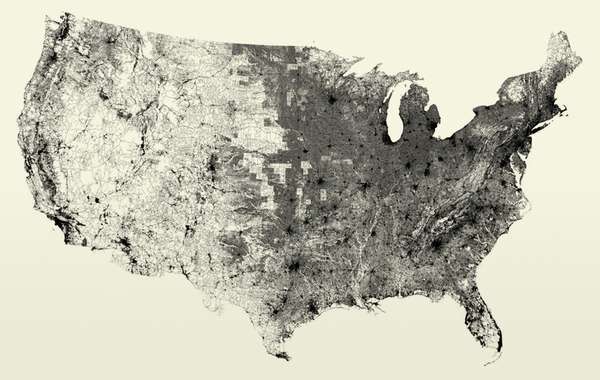
U.S. Circulatory System of Highways
Going Like Sixty — November 26, 2008 — Pop Culture
References: benfry
Some geeks just love playing around with data available on the web. I, for one, am glad they do, otherwise how would we ever have this map to help President Obama decide where to put new roads to bring the U.S. economy back to its feet? It’s obvious that the eastern half of the U.S. is OK. So I would say that Nevada, New Mexico, Colorado, Utah and those other western states need more roads. Alaska and Hawaii are omitted because we all know they don’t count because they aren’t connected to the real United States.
Trend Themes
1. Data-driven Transportation Planning - Analyzing data on traffic patterns and road infrastructure can help inform transportation planning decisions in the United States.
2. Geospatial Data Analysis - Mapping and analyzing geospatial data can provide valuable insights for government and business leaders in various industries, including transportation and logistics.
3. Predictive Analytics for Transportation - Leveraging predictive analytics algorithms can help anticipate traffic trends and inform infrastructure development in the transportation industry.
Industry Implications
1. Transportation and Logistics - Data mining and geospatial analysis can provide valuable insights for transportation planning and logistics management in this industry.
2. Government and Public Administration - Using data to inform infrastructure development decisions can help government leaders in their mission to serve the public and improve quality of life.
3. Technology and Software Development - Building software tools and algorithms for analyzing geospatial data can create disruptive innovation opportunities for tech companies in this industry.
2
Score
Popularity
Activity
Freshness


