


Identify Risk Zones and Enhance Preparedness With Nuclear Disaster Map
Ellen Smith — February 26, 2025 — Lifestyle
References: nucleardisastermap
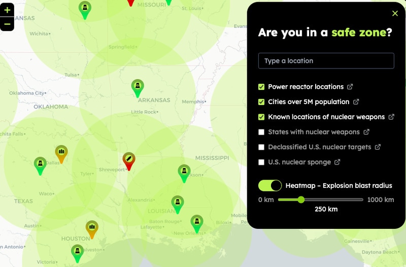
Nuclear Disaster Map is an interactive tool designed to provide users with insights into potential nuclear risk zones. By analyzing geographic data and historical trends, the platform helps individuals assess whether their home or workplace falls within a high-risk area in the event of a nuclear incident.
The tool can be valuable for emergency preparedness, urban planning, and risk assessment, allowing users to make informed decisions regarding evacuation routes, shelter options, and contingency planning. While it does not predict nuclear events, it serves as an educational resource that raises awareness of potential threats. Governments, businesses, and individuals focused on safety and preparedness can use Nuclear Disaster Map to enhance their understanding of nuclear risk factors, contributing to better crisis readiness and response strategies.
Image Credit: Nuclear Disaster Map
Trend Themes
1. Interactive Risk Assessment Tools - Emerging digital platforms that offer real-time analysis of geographical data are redefining how individuals and organizations perceive and prepare for potential risks.
2. Data-driven Urban Planning - Urban planners increasingly rely on data analytics to inform designs that enhance safety and mitigate disaster impacts in high-risk areas.
3. Educational Awareness Platforms - New platforms are educating the public about potential environmental threats, fostering a more informed and prepared society through accessible information.
Industry Implications
1. Emergency Preparedness Services - Companies in this sector are developing sophisticated tools and strategies to support individuals and communities in anticipating and responding to disasters.
2. Geospatial Analysis Technology - This industry is advancing rapidly as organizations demand more precise geographical data to assess environmental and disaster-related risks.
3. Strategic Urban Planning - Focusing on integrating risk assessments into development projects, this industry aims to design safer and more resilient infrastructures, particularly in vulnerable areas.
3.8
Score
Popularity
Activity
Freshness