Google Earth Unveils Buildings Layer
Going Like Sixty — December 19, 2008 — Tech
References: googleearthuser.blogspot
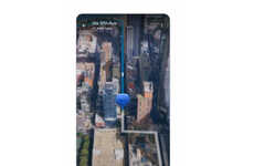
Excuse me while I gush over Google--again! I don’t know what’s gotten into the boys and girls at the Googleplex, but they are rolling out new features like the world is coming to an end. Gulp. Moving on: Google has 3D photo textures of nearly every building in Manhattan.
To try this insane feature out for yourself, fly to “New York City” and turn on the 3D Buildings layer in Google Earth. (Use the link below for help.) Just a year ago only a few buildings were represented. Now it’s possible to virtually fly above the streets. Amazing.
To try this insane feature out for yourself, fly to “New York City” and turn on the 3D Buildings layer in Google Earth. (Use the link below for help.) Just a year ago only a few buildings were represented. Now it’s possible to virtually fly above the streets. Amazing.
Trend Themes
1. 3D Mapping - The use of 3D photo textures to create detailed virtual models of buildings can revolutionize urban planning and architecture.
2. Virtual Tourism - The ability for individuals to virtually explore cities through detailed 3D modeling can open up new opportunities for tourism and travel.
3. Augmented Reality - The integration of 3D mapping technology into augmented reality applications can create new immersive experiences for users.
Industry Implications
1. Architecture - The ability to create highly detailed 3D models of buildings can greatly enhance the design and construction process.
2. Tourism - Virtual tours of cities using 3D mapping technology can offer travelers a unique and immersive experience.
3. Gaming - The incorporation of 3D building models into video games can create more realistic and engaging gaming environments.
3.2
Score
Popularity
Activity
Freshness

