These David Thomas Smith Satellite Photographs Play with Perception
Jana Pijak — March 21, 2013 — Art & Design
References: materialicious & thecopperhousegallery
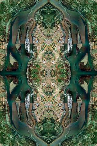
Entitled "ANTHROPOCENE", these David Thomas Smith satellite photography stills capture kaleidoscopic areal views of various global landscapes. From dry deserts and rocky mountain tops to lush greenery and untouched forests, these dynamic i images play with perception.
The Dublin based artist is a graduate of the University of Wales, Newport where he obtained a degree in Documentary Photography. Known for always experimenting, David Thomas Smith creates visual masterpieces that test visual boundaries.
Smith's work is comprised from thousands of digital files that are created from aerial view satellite images. From explorations of the third dimension to themes affecting social and political issues, the artist captures complex and meaningful photographs that are conscious of important subjects while retaining their air of aesthetic richness.
Trend Themes
1. Kaleidoscopic Satellite Photography - Opportunity for businesses to use satellite images to create unique and visually striking marketing materials.
2. Aerial View Technology - Possible innovation to improve and expand applications of aerial view technology, including mapping and surveillance.
3. Perception-altering Art - Opportunity for businesses to work with artists and designers to create thought-provoking and visionary campaigns.
Industry Implications
1. Marketing and Advertising - Potential for marketers to use satellite imaging technology to create visually engaging advertisements.
2. GIS and Mapping - Potential for GIS and mapping companies to expand their services with improved aerial view technology.
3. Fine Arts and Photography - Possibility for fine arts and photography businesses to incorporate satellite imaging into their work.
3.6
Score
Popularity
Activity
Freshness

