NASA Helps to Capture Monstrous Hurricane Sandy Pictures
Cody Turner — October 29, 2012 — Tech
References: buzzfeed
With the storm just moments away from hitting New York City, people want to see Hurricane Sandy pictures to see just how big this storm really is.
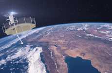
A lot of these photos were taken from satellites provided by NASA and as you can clearly see, this is going to be a big one. The storm clouds have been picking up speed over the water and the wind speeds are reaching over 90 miles per hour, which is up from 75 miles per hour just yesterday.
You can see just what the storm look like when viewed from the International Space Station, a radar view of New York and the Northeast and also in a photo of Hurricane Sandy in infrared.
Trend Themes
1. Satellite Imaging - Companies in the meteorology and disaster prevention industries can leverage satellite imaging to improve their services and provide detailed data to clients.
2. Radar Technology - The radar technology industry can innovate by developing faster and more accurate ways of capturing and analyzing weather data, which will enhance emergency response teams' abilities to predict and respond to potential natural disasters.
3. Remote Sensing - Remote sensing could be used in a variety of industries from agriculture and forestry to energy and urban planning to use real-time, accurate data to make informed decisions and improve efficiency.
Industry Implications
1. Meteorology - In addition to providing real-time weather data, meteorological companies and agencies can leverage satellite imaging technology to provide clients with precise information about climate conditions and natural disasters.
2. Emergency Management - The emergency management industry can make use of advanced radar and remote sensing technologies to improve response times and protect people and property during natural disasters.
3. Agriculture - Remote sensing can help farmers and agricultural experts to collect detailed data that can be analyzed to make well-informed decisions about planting, harvesting and land management.
6.2
Score
Popularity
Activity
Freshness


