The Updated Google Earth Mobile Edition Features Custom Maps
Sarah Moore — March 25, 2012 — Tech
References: google
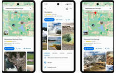
The newly updated Google Earth mobile application for Android and Apple mobile operating systems allows users to reap the same super detailed geographical information that is available on the desktop version of the application on-the-go and at the palm of their hand.
Perhaps one of the most beneficial features of the mobile application is the ability to download "Keyhole Markup Language" files that contain specific and relevant information about the earth's structure. Having this kind of information at one's fingertips would be extremely beneficial to travelers visiting new places as they can easily get a sense of their surrounding landscape right from their phone.
The updated Google Earth mobile app also includes an 'Earth Gallery' that displays a list of preselected maps that not only describe but also display real-time changes to the landscape. When devastating events such as earthquakes shake the world, users would be able to know exactly where and when it happened and what the impact was. The feature also includes relevant information such as listing nearby tourist attractions and hiking trails.
Trend Themes
1. Mobile Geographical Information - The updated Google Earth mobile app allows users to access detailed geographical information on their mobile devices.
2. Keyhole Markup Language Integration - The ability to download KML files on the Google Earth mobile app provides users with specific and relevant information about the earth's structure.
3. Real-time Landscape Changes - The 'Earth Gallery' feature in the Google Earth mobile app displays preselected maps that show real-time changes to the landscape, including natural disasters and tourist attractions.
Industry Implications
1. Travel and Tourism - The mobile geographical information trend presents opportunities for travel and tourism companies to provide more in-depth and real-time information to travelers visiting new places.
2. Mapping and Navigation - The integration of Keyhole Markup Language in the Google Earth mobile app opens up disruptive innovation opportunities in the mapping and navigation industry by enabling more comprehensive spatial data analysis.
3. Emergency Response and Disaster Management - The real-time landscape changes trend in the Google Earth mobile app offers potential benefits for emergency response and disaster management organizations to track and respond to natural disasters more effectively.
3
Score
Popularity
Activity
Freshness


