Here Translates Big Data Through 3D Mapping Tools
Jana Pijak — November 16, 2015 — Tech
References: youtube & inavateonthenet.net
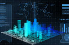
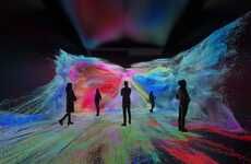
Partnering with spatial branding agency Graft Brandlab, 3D mapping company Here created this immersive smart city projection. The projection brings a San Francisco city map to life and translates big data through three-dimensional forms. Showcasing a 3D transportation infrastructure -- everything from traffic patterns to wireless internet waves -- this CNC-cut sculpture is turned immersive with the help of modern technology.
In addition to allowing a connected transportation infrastructure to come to life digitally, Here's 3D mapping technology can also be used by architects, urban planners and designers who wish to translate their vision in a more immersive way.
This projection uses real data to explain, perfect and test urban planning concepts before they become a reality, making it a powerful presentation tool for those designing the world's smart cities.
Trend Themes
1. Immersive 3D Mapping - The use of 3D mapping technology to create immersive experiences and translate big data into three-dimensional forms.
2. Connected Transportation Infrastructure - The integration of digital technology and data in transportation infrastructure to enhance connectivity and efficiency.
3. Smart City Visualization - The use of real data and advanced visualization techniques to explain, perfect, and test urban planning concepts.
Industry Implications
1. Spatial Branding - The use of spatial branding techniques to create immersive experiences and connect with audiences in physical spaces.
2. Architecture - The incorporation of 3D mapping technology in architectural design processes to create more immersive and interactive presentations.
3. Urban Planning and Design - The use of advanced visualization tools, such as 3D mapping, to improve urban planning and design concepts and facilitate decision-making.
2
Score
Popularity
Activity
Freshness


