The World Metro Map Combines 214 Subway Maps Across Five Continents
Malika Renee Butss — January 20, 2016 — World
References: kickstarter & fastcodesign
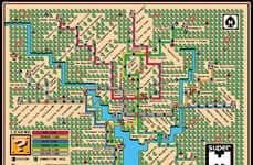
New York-based collective ArtCodeData designed a global subway map, which it appropriately calls the 'World Metro Map.' This massive map features 214 subway systems from cities all over the world.
Linking worlds that are divided by land and sea, the World Metro Map is a creative design that links 214 subway systems and unifies them as one single map. The digital collage features 791 subway lines and 11,924 stations, which go from New York all the way to Tokyo. Its map style is based on the diagram of the Tokyo Metro System, but it features stations from countless others.
Though there is an artistic flair to the colorful way these lines intersect, there is a specific layout to the subway madness. While the oldest subway systems connect in the middle, the newer ones are located on the outskirts of the map.
Trend Themes
1. Global Subway Maps - An innovative trend in creating comprehensive subway maps that connect cities worldwide, providing a unified view of public transportation systems.
2. Digital Collage - The use of digital collage techniques to combine subway maps from different cities and create visually stunning representations of global transportation networks.
3. Artistic Flair - The incorporation of artistic elements in subway map designs, utilizing creative colors and intersections to enhance readability and visual appeal.
Industry Implications
1. Transportation - The transportation industry can benefit from the development of unified global subway maps, facilitating seamless navigation for commuters and tourists alike.
2. Technology - The digital collage techniques used in creating global subway maps present opportunities for technology companies to develop innovative mapping and visualization solutions.
3. Design - The incorporation of artistic elements in subway maps opens up opportunities for designers to create visually appealing and engaging public transportation maps.
2.9
Score
Popularity
Activity
Freshness

