ROCK Robotic Releases a New Product for Survey-Grade Mapping
References: rockrobotic & dronelife
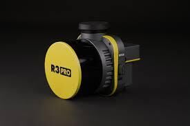
ROCK Robotic, a LIDAR technology company, is introducing the R3 and R3 PRO mapping systems. With features like geodetic-grade GNSS receivers, high-resolution RGB image capture, and tactical-grade IMU, the R3 lineup is a great option for surveyors, engineering, mining, utility, and mapping professionals. Compared to the previous model, the device weighs just 1.26 kg, making it perfect for traveling. The 'R3 PRO' uses the improved Hesai Pandar XT32 sensor, while the R3 uses the Hesai Pandar XT16 sensor.
“The ROCK R3 PRO is a major step forward for ROCK Robotic,” said ROCK Robotic CEO Harrison Knoll. “It offers better accuracy, better SLAM, a better camera, a lighter payload — basically a better product all around. Not only will our current customers love it, but we’re confident that the R3 will attract new customers who want a great hardware product along with our great software and support.”
Image Credit: ROCK Robotic
Trend Themes
1. LIDAR Mapping - The introduction of LIDAR technology for survey-grade mapping presents opportunities for companies to develop disruptive mapping products and services.
2. Geodetic-grade GNSS - The use of geodetic-grade GNSS receivers in LIDAR mapping systems creates opportunities for precise and accurate mapping of areas, leading to more efficient and effective planning and execution of projects.
3. Tactical-grade IMU - The inclusion of tactical-grade IMU systems in LIDAR mapping systems can lead to new innovations that enable more accurate and efficient data collection.
Industry Implications
1. Surveying - The R3 and R3 PRO mapping systems present an opportunity for surveying companies and professionals to improve the accuracy and efficiency of their work.
2. Engineering - The advancements in LIDAR mapping technology create an opportunity for engineering firms to develop new products and services that can improve the accuracy and efficiency of their work.
3. Mining - The use of LIDAR mapping systems can improve the safety and efficiency of mining operations, creating opportunities for companies to develop new products and services that meet these needs.
4.5
Score
Popularity
Activity
Freshness

