Elevation and Sea Depth Can Analyze Terrain Up to Five Kilmeters
Ellen Smith — August 1, 2024 — World
References: play.google
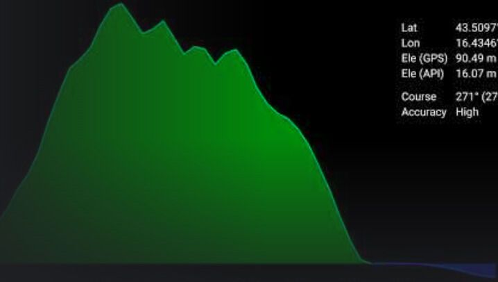
Elevation and Sea Depth is a versatile app designed to provide real-time elevation and sea depth profiles based on the direction your phone is facing. Ideal for outdoor enthusiasts such as hikers, trekkers, mountaineers, and fishermen, the app offers detailed terrain analysis with a range of up to five kilometers.
It provides elevation data points every 10 meters or 100 meters horizontally, giving users a comprehensive view of the terrain’s profile. Directions are rounded to 30-degree steps to simplify navigation and improve accuracy. This tool helps users anticipate changes in elevation or sea depth, enhancing their experience and safety during various outdoor activities. By offering precise and actionable terrain information, the app supports more informed and enjoyable explorations.
Image Credit: Elevation and Sea Depth
Trend Themes
1. Real-time Terrain Analysis - Real-time terrain analysis empowers outdoor enthusiasts with precise elevation and sea depth data, enhancing exploration safety and experience.
2. Mobile Navigation Enhancements - Innovations in mobile navigation apps offer detailed topographical information, simplifying route planning for hikers and trekkers.
3. Comprehensive Outdoor Apps - Comprehensive outdoor apps that provide detailed terrain profiles cater to the needs of adventurers, promoting well-informed and enjoyable outdoor activities.
Industry Implications
1. Outdoor Recreation - The outdoor recreation industry benefits from apps that offer real-time terrain analysis, making activities like hiking and fishing more informed and safe.
2. Mobile Technology - Advancements in mobile technology enable more sophisticated navigation and terrain-analysis apps, revolutionizing the way users interact with their environment.
3. Geospatial Analytics - The geospatial analytics sector sees opportunities in developing applications that provide detailed, real-time elevation and sea depth data for various uses.
2.7
Score
Popularity
Activity
Freshness

