'DigitalGlobe' Allows Users to Spot Earthquake Damage
Katherine Pendrill — April 25, 2016 — Tech
References: digitalglobeblog & fastcoexist
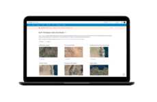
In the aftermath of Ecuador's devastating earthquake on April 16th, satellite imagery company DigitalGlobe launched an initiative that leverages the power of crowdsourcing to map damage. A similar project was launched in Nepal in 2015 and now the same technology is being used to help the victims of Ecuador's earthquake.
The project is called 'Tomnod' and it is run by DigitalGlobe. The project uses the power of crowdsourcing to let volunteers at home map earthquake damage remotely. Users can find and tag damaged buildings, roads and other areas that have been damaged by comparing before-and-after images posted by the company. The images are then shared with the Humanitarian OpenStreetMap Team, which works with rescue workers on the ground to identify where help is needed most.
The project demonstrates how the power of crowdsourcing can be used in emergency situations to improve the speed and efficiency of rescue crews.
Trend Themes
1. Crowdsourced Disaster Mapping - Companies are leveraging crowdsourcing to map earthquake damage and help victims in affected areas
2. Before-and-after Comparison Technology - Technology that compares and tags before-and-after satellite imagery can improve the efficiency of rescue workers during emergency situations
3. Humanitarian Openstreetmap Team - Collaboration between open-source mapping platform and rescue workers is an effective way to identify areas where help is needed most
Industry Implications
1. Satellite Imagery - Satellite imagery companies can leverage crowdsourcing to develop new disaster mapping services
2. Emergency Response - Emergency response teams can improve their effectiveness through technology and crowdsourcing initiatives
3. Open-source Mapping - Open-source mapping platforms can collaborate with other industries to create innovative solutions in disaster relief efforts
0.4
Score
Popularity
Activity
Freshness

