Axis Maps Use Street Names to Form the Streets Themselves
Meghan Young — October 13, 2010 — Art & Design
References: fastcodesign & gizmodo
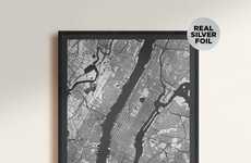
Axis Maps has cleverly designed maps solely using typography. Though the idea of typographic maps is not a new one, these Axis Maps boast an intricacy and attention to detail like no other.
These Axis Maps use actual street names to create the streets themselves. Currently, only maps of Chicago and Boston exist at $30 each. Check out how ridiculously detailed these maps are in the featured gallery.
These Axis Maps use actual street names to create the streets themselves. Currently, only maps of Chicago and Boston exist at $30 each. Check out how ridiculously detailed these maps are in the featured gallery.
Trend Themes
1. Typography Maps - Disruptive innovation opportunity: Explore new ways to incorporate typography in map design for enhanced visual appeal and functionality.
2. Intricate Map Design - Disruptive innovation opportunity: Develop innovative techniques to create highly detailed maps using advanced design technologies.
3. Street Name Visualization - Disruptive innovation opportunity: Find new methods to visually represent street names in maps for improved readability and navigation.
Industry Implications
1. Cartography - Disruptive innovation opportunity: Integrate advanced technologies like augmented reality and artificial intelligence in map-making process.
2. Graphic Design - Disruptive innovation opportunity: Collaborate with cartographers to explore new visual techniques that merge graphic design principles with map creation.
3. Tourism - Disruptive innovation opportunity: Create interactive map applications that combine typography, street names, and additional travel information to enhance tourist experiences.
1.6
Score
Popularity
Activity
Freshness


